Example Scenario: A Faulty Image on the Moon
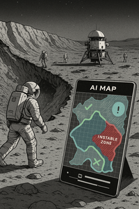
Image: AI generated with Copilot (Microsoft) "Astronauts at the crater rim, a green-marked zone, the unstable dust slope and the critical situation."
Initial Situation An international team is preparing an EVA (Extra-Vehicular Activity) near a crater area. Mission planning is based on an AI-generated map that visualizes resources (water ice deposits) and hazard zones (unstable regolith fields).
The Error
- The map shows a green-marked zone as a “safe path.”
- Due to missing semantic validation, a dust slope with high instability was falsely classified as walkable.
- The team relies on the visualization – semantic precision is lacking.
1. Operational Risks on the Moon
- Dust and regolith: Lunar dust is extremely fine, sharp-edged and electrostatic. It could damage equipment, impair visibility, and endanger health.
- Unstable terrain formations: Crater slopes and loose regolith fields could give way under load.
- Communication disruptions: Dust clouds could impair sensors and devices.
2. Diplomatic and Legal Dimension
- Resource claims: Water ice in polar regions is considered strategically important. If a map incorrectly depicts ownership or resource zones, it could trigger international tensions.
- Cultural sensitivity: Symbols or representations that distort religious or cultural meanings could be diplomatically sensitive.
3. Visuals as Operational Truth
- In spaceflight, visualizations are not mere “decoration” but action-guiding tools. Maps, diagrams, and symbols determine routes, resources, and safety.
- A faulty image could directly lead to wrong actions and thus to accidents or conflicts.
Consequence without the Framework
- Astronauts may enter the zone.
- The ground collapses, dust clouds impair visibility, communication devices are disrupted by particles.
- Life-threatening danger arises from oxygen loss and radiation exposure.
- Additionally: The map is shared publicly – other nations interpret the false depiction as a resource claim. A possible diplomatic conflict could escalate.
This is intended as a plausible projection of what could happen if semantic validation is missing.
Where Does the Semantic Integrity Framework Intervene?
Prevention through Semantic Validation
Auditable modules check the image data:
- Risk classes are automatically compared with predefined thresholds.
- Uncertainty encodings (e.g., hatching, color transparency) clearly show that the zone is not validated.
Role-based governance:
- The map should carry a responsibility label (“Geology team validated”).
- Every representation is linked to provenance chains – clearly traceable as to who reviewed the data.
Result
- The team immediately recognizes: The zone is unsafe and not approved.
- An alternative route is chosen, the mission remains safe.
- Publicly shared maps contain semantic markers that prevent misunderstandings.
- Instead of conflict, trust emerges, as the representation is transparent and verifiable.
A single faulty image on the Moon can endanger human lives and trigger international tensions. The Framework ensures that visuals are auditable, semantically precise and culturally respectful, transforming them from a risk into an operational backbone for safety and governance.
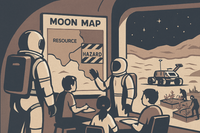
Image: AI generated with Copilot (Microsoft)